Choose Tibet classic tour ... Discover the highlight of Tibet.follow with the Tibetanstravel.com tour expert,Enjoy them enthusiati... Discover the highlight of Tibet.follow with the Tibetanstravel.com tour expert,Enjoy them enthusiati... |
The highlight of Tibet in-... Explore the world"s Ten topest tour destination of Tibet,Choice a richest experience Tibetan to... Explore the world"s Ten topest tour destination of Tibet,Choice a richest experience Tibetan to... |
Experience the vibrantion ...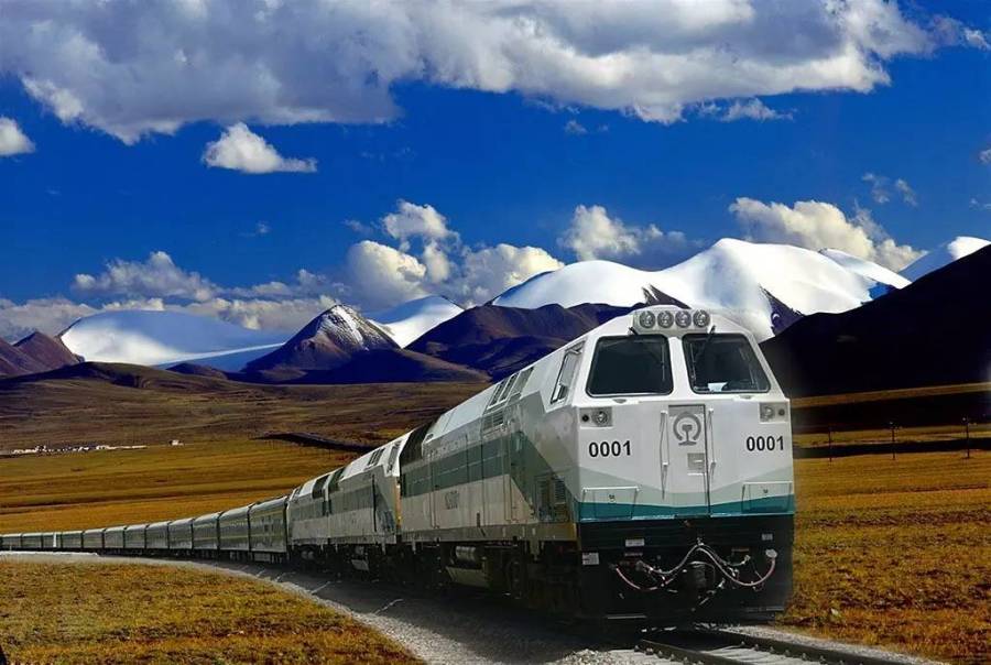 Take a train tour from China to Tibet along with the Qinghai_Tibet railway to appreciate and experie... Take a train tour from China to Tibet along with the Qinghai_Tibet railway to appreciate and experie... |
Tour code-TO01 : 21days Ti...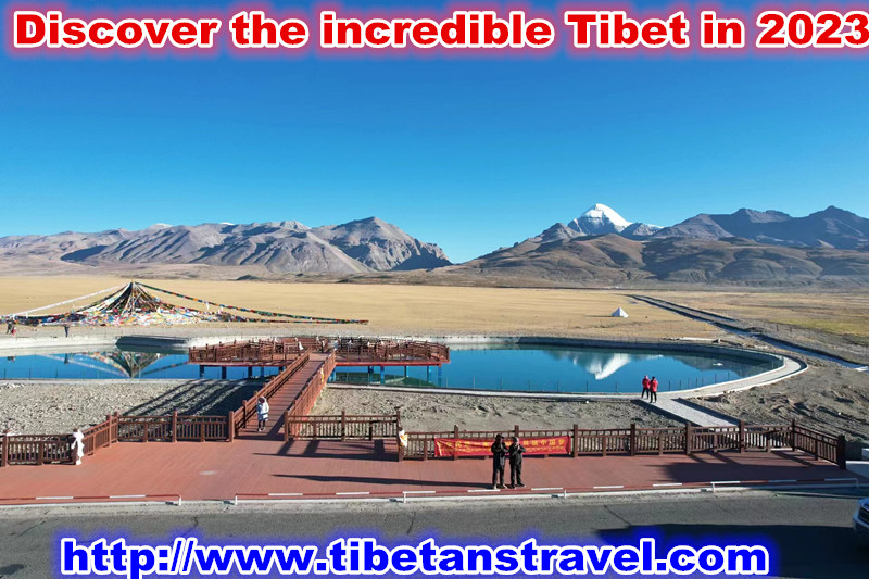 Best visit time: May-Sept Elev:3600m-5200m Best visit time: May-Sept Elev:3600m-5200m |
Tour code-TO02 : 10days Ne...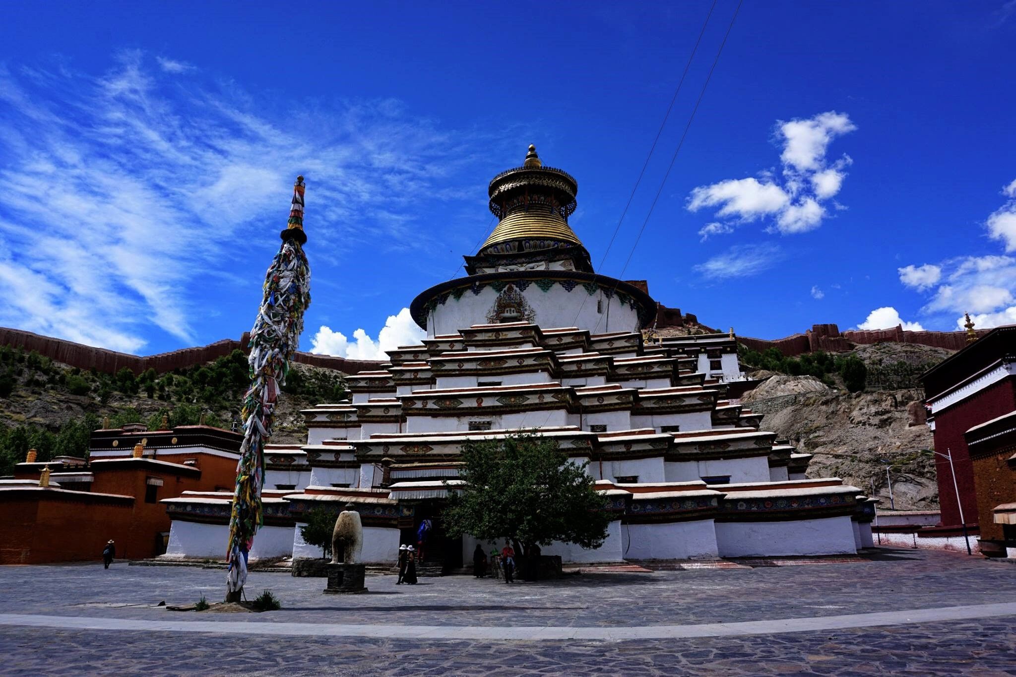 Best visit time:April-Oct Elev:3600m-5200m Best visit time:April-Oct Elev:3600m-5200m |
Tour code-TO03 : 11days Qi... Best visit time : March-Oct Elev:2500m-4700m Best visit time : March-Oct Elev:2500m-4700m |

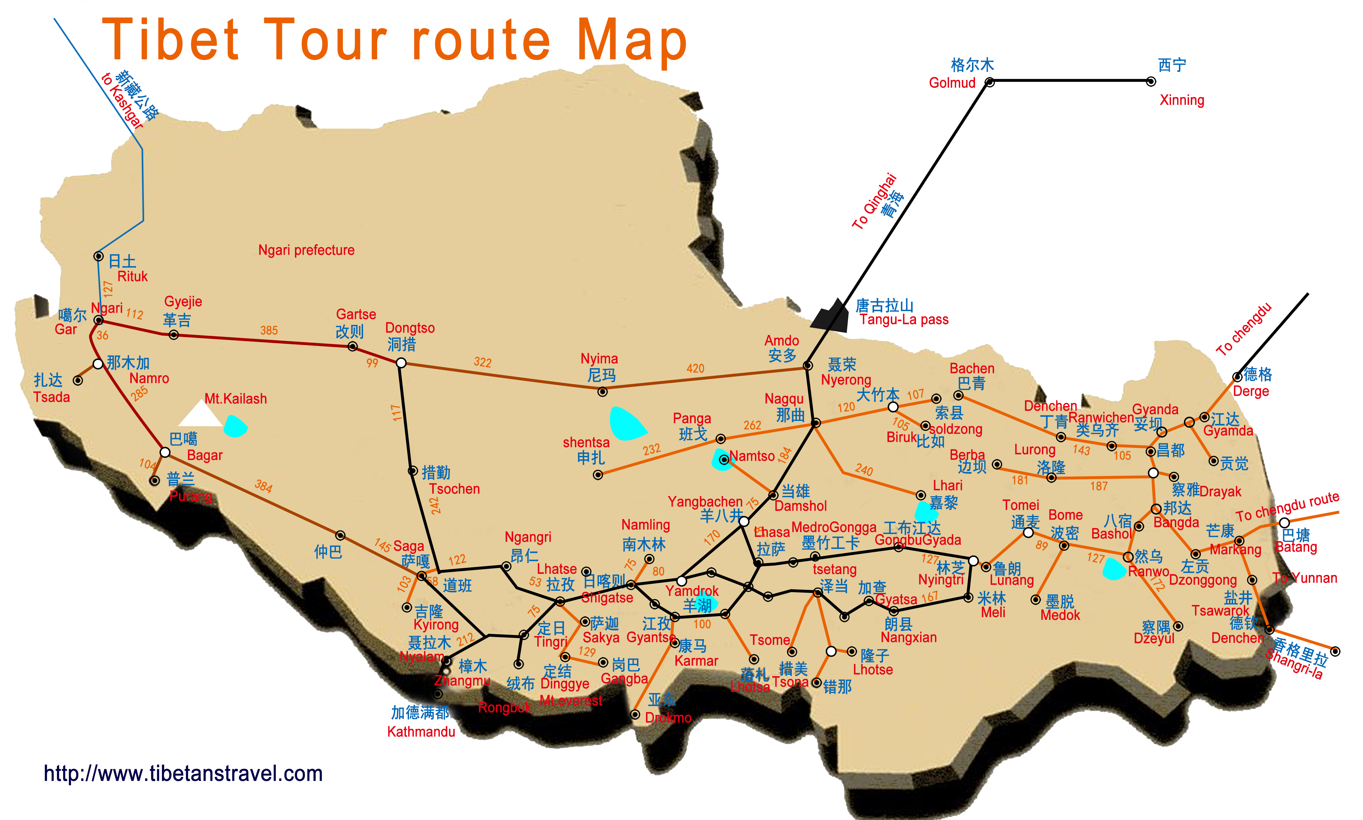
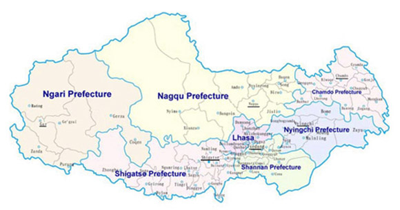
Tibet Map
Those maps dedicated to help you understanding the Tibet basicl administration region and the geography feature before you consider plan the Tibet tour and also help you to know every scenics distribution site in Tibet.
- Tibet area: 123million
- Population:320,000,000
- Elevation:average above 3600m
- language:Tiibetan ,Chinese ,english
- Best travel Season: Apri- Oct
- Climate: High degree +28.C, Lower degree-05.C
- Main Tourist town : Lhasa. Lhokar(in Chinese Shannanshi),Nyingtri(In Chinese Linzhishi), Chamdo,Shigatse.Nagqu,Agari
Tibet,the land of the snow ,the roof of the world,it is known as the world’s last pure land-Shangri-la,and one of the most remarkable place in Asia,Due to its special highland geographically topography and carry over into the thousand more years Tibetan unique magic Buddhist culture make it a sacredness region in world ,therefor became a world's golden tourist destination
The Tibet autonomous region(TAG) is located in the Qinghai-Tibet plateau and in southwest of china frontier,is one of the second largest region in china the total area of the Tibet autonomous region is 1,23milionSq km with it population 280,000.000, the Tibet is bound to the south by Nepal ,Indian, Bhutan,Burma.,to the north by Xinjiang and Qinghai, to the east by the Sichuan ,to the southeast by Yunnan,to the west by the Kashimer,the boundary line is as long as 4000 km,
Tibet has a varied topography divide into three different natural part, The eastern part is a green forest region, occupying approximately one-fourth of the land. Virgin forests run the entire breadth and length of this part of Tibet. The northern part is an open grassland where nomads, yaks and sheep dwell. This northern part occupies approximately half of Tibet. The southern and central part is an agricultural region, occupying about one-fourth of Tibet's land area. With all the major Tibetan cities and towns such as Lhasa, Shigatse, Gyantse and Tsetang located in this area, it is considered the cultural center of Tibet. The region is administratively divided into one municipality (Lhasa) and six prefectures (Shigatse, Ngari, Lhaoka, Chamdo, Nakchu and Nyingtri (Kongpo)).with 72 counties,
2- Lhasa map
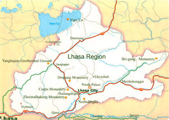 About Lhasa
Population :550,000
Area:30000sqkm
Elevaion:3650m
Attractions:Potala palace ,Jokhang temple
Ramchen temple 。Drepung &Nechung monastery, Sera & Pabonka monastery,
Ganden monastery ,Tsurph monastery, ,Namtso Lake ,Reting monastery,Talung monastery,Drigun-til onastery,Tidrumnunnery&hot spring,Drakyerpa,
Introduction:
The holy city of Lhasa is the historic captial of Tibet,situated on The north Bank of the Kyichu river,where the valley opens out to its fullest extend,To the North of the city lies any impenetrable 5,200 range,extending from Mt Gerphel Utse to Mt Dukri Tse and Mt Sera Utse,to the South on the far bank of the river is the Chakyak Karpo range,Smaller hills are located within the valley,the most prominent being Marpori on which the ‘Potala palace is constructed,
The Lhasa rose to prominence as an important administrative centre in the 7th century AD, when the Tibet king Songtsen Gampo(c 618-49),a local ruler in the Yarlung valley continued the task initiated by his father of unifying Tibet ,Songtsen Gampo moved his capital to Lhasa and built a palace on the site now occupied by the Potala,At this time the temple of Jokhang and Ramchen were established to house Buddh images brought as the dowries of Songten Gampo’s chinese and nepali wives ,from the fifth Dalai lama moved his capital to Lhasa,he rebuilt the Potalace on the site of ruins of Songtsen Gampo’s 7th century palace,Lhasa has remained Tibet capital from 1642.and most of the city’s historiccal site date from this second satge of the city’s development,
3- Shigatse prefecture map
 About Shigatse
Area:18,2 sqkm
Population 630.000
Elevation:3850m
Attractions: Tashilunpo monastery,
Pelkor cheden Choden&Kumbum,Dzong casttle ,Shalu monastery monastery,Sakya monastery,Mt everest ,
Cho-oyu ,Makalu ,Lhotse
Introduction:Shigatse is situated at the juncture of the Brahmaputra river and Nyanchu river,about 280km southwest
of Lhasa,it is a second-largest town and the traditional capital of Tsang area.Since the Mongol sponsorship of the Gelupa order,Shigatse has been the seat of the Panchen Lama.traditionally based in Tashilunpo monastery,Tashilunpo monastery is a highlight of Tibet and Shigatse’s foremost attraction. The Shigatse ,formerly known as Samdruptse,has long been an important trading and administrative center for Tsang area ,The Tsang kings exercised their power from the once imposing heights of the Shigatse Dzong_the present ruins only hint at its former glory _and the fort later became the residence of the governor of Tsang, the original town is huddled at the foot of the fort and a rapidly expanding modern town that has seen a huge influx of capital in these recent year. The city slightly higher than lhasa at 3,900m with an oxygen content of 67% and average annual temperature are 16C in mid summer and – 5c mid winter,
4- Tsetang map
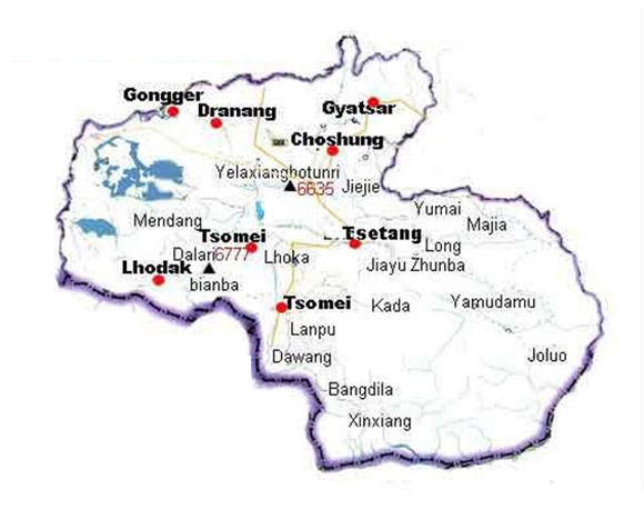 About Tsetang
Population 330000
Area :7.97sqkm
Elevation:3500m
Attraction: Samye monastery ,Chim-puk hermitage.Mindroling monastery,
Yumbulakhang ,Trandrok monastery,
Chonggyel tomb of Tibet kings .
Gongpori .Dorjir Drak monastery,
Yamdrok-tso Lhamolatso
Introduction: The Tsetang is situated the north bank of Brahmaputra river ,it is one of the Tibet largest city,and the capital of shanan prefecture of the Tibet autonomous region ,exercising direct control over the affairs 13 countys and the elevation is 3500m with the population 318.000,the town is considered to be cradle of the Tibetan civilization, and it was from Yarlung that the early Tibetan kings unified Tibet in the 7century,The massive burial mounds of these kings can be see in Chonggye ,Yumbulagang,another major attraction of the area,is perched on a crag like a medieval European castle and is reputed to be Tibet’s oldest building,
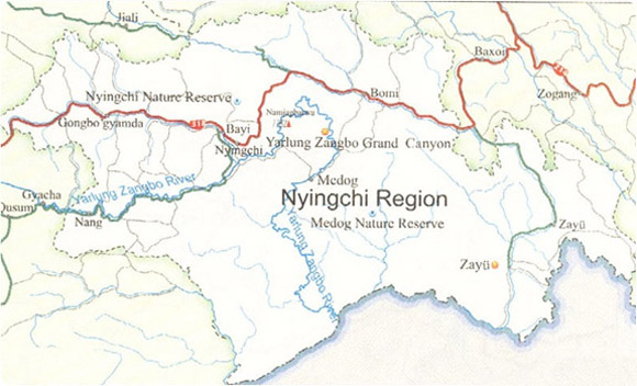
5- Nyingtri precture region(Kongpo)map
 Population:146.000
Area:117000sqkm
Elevation:29000m
Attractions:Draksum-tso
,Lamaling monastery ,
Buchu monastery,
Namchenbarwa(7756m),
Gyala Pelri()7151m),
Ranwok lake. Brahmaputra gorges
Introduction:
Nyingtri is located south part of Tibet ,it is far from lhasa 430km at The Tibet –sichuan high way, the Nyingtri lowest in height among the 7 prefecture in Tibet ,the capital town is called from Chinese Bayi, the Nyingtri prefecture whole area is covered by a dense and evergreen virgin forest which is biggest in Tibet, the average elevation 3000m sea lelevel ,the climate is relatively humid and warm, the town of Bayi which once occupied this strategic site, has been completely absorbed by the recent urban development ,is one of the important town of the sichuan-Tibet highway and Yunnan-Tibet hwy. The Nyingtri also in Tibet called Kongpo,is one of the important town on Sichuan-Tibet Hwy and Yunnan-Tibet Hwy.
The Kongpo region is culturally ,ecologically and linguistically quite distinct from the rest of Tibet,a former kingdom of the early Yarlung kings and rival to Lhasa,Kongpo has for centuries been viliffied by central Tibetan rulers as a land of incest and poison,where stranger are routinely drugged,so that the locals can steal their soul,along the road to Draksun-tso,look out for the tall12-side stone towers, these are referred to locally as Dudkkhang,
6- Ngari prefecture region map
 About Ngari
Populatio:90,0000
Area:345。000sqkm
Elevation:3500m
Main attraction: Mt Kailash ,Manasorovar,
Tirthapuri&Hotspring ,
Guge kingdom ruin ,
Tsaparang Dunkar&piyang
Tholing monastery,
Pangong-tso
Introduction:Ngari is located far-west of the Tibet and the capital of the Ali prefecture of the Tibet Autonomous Region,it is a important town for the Tibet-Xingjiang highway.the Ngari prefecture average altitude over the 4500m and an area of 300.000 sq km,it is second largest area in Tibet Autonomous Region and adjoined with the Kashigar to the west and Shigatse prefecture to south east,Nepal and Indian ,Kashimr to the southeast, The Ngari prefecture has jurisdiction 7 county as Tsada,Purang,Gar,Rutok,Gakyi,Gertse and Tsochen,the town of ali now became politic ,cultural .economy center for this prefecture,
7- Chamdo prefecture region map
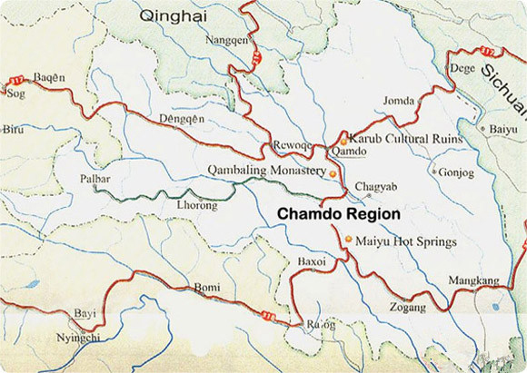 About Chomdo
Population:620,000
Area :118600sqkm
Elevation:3500-4500m
Attractions:Chamdo gendan Jampling monastery,Riwochen tsuglhakang
Iintroduction :Chamdo literally “junction of river”is located in ea
Chamdo (literally meaning river confluence)usually refer to the city of Chamdo,which straddles the Mekong at the point where its Ngom-chu and Dza-chu branches converge,which is administrative headquarters for 11 counties of Kham,extending from Tenchen to Jomda in the north and from Pasho to Markham in the South,the Chamdo also is a
Central town in Khampa region and regarded as the eastern gate of Tibet, The area around of Chamdo was one of the first settled in Tibet, as attested to by the 5000year-old Neolithic remained at nearby Karo,fossilised milliet hints at a 5000-year tradition of agriculture in the region, the Chamdo is aslo a of Khampa region culture ,religious ,political central in east Tibet ,and the Kham region was the home of many holy men including the founders of the Drigungpa and Karmapa school,in 1070,Many buddhists fled presecution in central Tibet to Kham,where they set up influential monasteries later returning to Tibet to spearhead,the so-called second diffussion of Buddhism in Tibet,
8- Nagqu precture region map
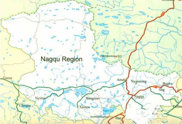 About Nagqu
Population 390,000
Area:420.000sqkm
Elevation:4500m
Main attractions:Sok-tsanden monastrey , Jangtang grassland ,
Tsona lake ,Nyanchen Tangla
Kekexil wildlife perserve area
Introduction:Nagqu is located in the north part of Tibet ,traditionally known as Jang Nagquka.is the name given to the high nomadic terrain of the E Jangtang Lakes and the Salween headwater,the average altitude 4500m.this is a vast wildness region through which the Nagchu Shak-chu and Sok-chu tributaries flow to from the Salween ,a 2.784km river rising in the Dangla range to the N,which has its estuary at the Gulf of Martaban, S of the Burma ,the city of Nagchu,which has undergone unprece-dented development within the last 2 years, is the administrative capital of nine counties within the upper Salween region ,as well as having its own county level bureaucracy .
9- The map of the Qinghai-Tibet railway
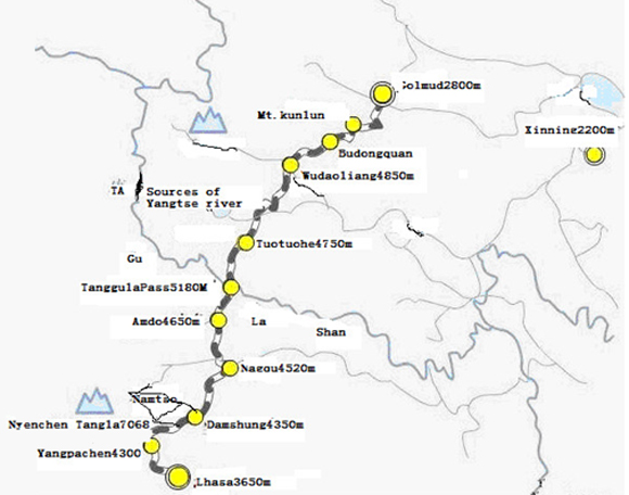 Name:Qinghai-Tibet railway
Distance:1970kkkm
Start: Xinning of Qinghai province
End:Lhasa of Tibet
Train running hours:20hrs
Train stop station on way:Delingha(10minute)Golmud(40minute)Nagqu(10minute)Damshung(10minute)
Highlight :Kokonor lake(Qinghailake) Kunlun mountain renge scenery Kekexili wildlife protection area,Tibet antelope ,Tsona lake, The north Tibet grassland.
10) The railway Running cities between China and Lhasa map
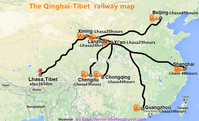 1Beijing-Lhasa Running Time 41hrs
2Shanghai-Lhasa Rungning time 46hrs
3Guangzhou-Lhasa Running time48hrs
4Chongqing-Lhasa Running hr 38hrs
5Chengdu-Lhasa Running times 39hrs
6Lanzhou-Lhasa Running time 24hrs
7Xinning-Lhasa Running time 21hrs